Who doesn’t love a local carnival and parade? If you’ve ever spent the spring in Charlottesville, you may be familiar with The Charlottesville Dogwood Festival, either through attending it yourself or hearing it described by locals and through media coverage. This pleasant event full of diverse activities has a rich local history, dating back to 1950. This years festival will be held April 7-24th. Read on to learn more about how The Charlottesville Dogwood Festival came about, some of its important milestones, and how it has evolved through the years.
The Charlottesville Dogwood Festival is a popular two-week long springtime event and tourist attraction in Charlottesville, VA, featuring multiple festive happenings and celebrations, including the parade, fireworks, and a carnival. The festival, first carried out in 1950 as an Apple Harvest Festival, aims to exhibit the Charlottesville and Albemarle areas’ cultural and historical heritage and rich natural beauty, and succeeds in doing so to this day.
The Apple Harvest Festival in 1950 was originally held in the fall and was instituted to celebrate and draw attention to Charlottesville’s vibrant culture and booming trade, and specifically to the local apple production industry. Like the current Dogwood Festival, it involved a grand parade and carnival and the choosing and honoring of an annual festival queen. Nancy Hughes was the first Apple Harvest Queen and after her coronation a Queen’s Ball in her honor was thrown at the conclusion of the festival.
The festival’s first president, Sol Weinberg, was a prominent business leader at this time and played many roles in Charlottesville. He was born in nearby Staunton, attended UVA, served on the Charlottesville School Board, and was elected to Charlottesville City Council. He financed the first festival and was appointed mayor of Charlottesville in 1954.
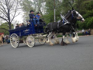 The early years of the festival were exciting and successful. The Charlottesville Municipal Band was a staple of the early Dogwood Festival parades. The Charlottesville Municipal Band was formed in 1992 and has been performing continually ever since. You can still expect to see them at the festival. In 1951 the Belmont Bridge was closed because of the immensity of the festival parade and observers stood in the street intersections near the bridge to watch. Businesses took advantage of the massive parade crowds and both supported floats and ran advertisements on wagons in the parade. Local scouting and civil service organizations also traditionally participated in the parade. Awards were and still are given out for parade floats. In 1951 and again in 1953, a team of acrobats performing in the street without nets were a popular parade attraction. In 1956, a pet show was incorporated into the festival and sponsored by the Charlottesville Kennel Club.
In 1958 the name of the festival was changed to The Charlottesville Dogwood Festival in honor of the Virginia state tree and flower. Variations of the Virginia dogwoods (which are woody plants of the cornus species) grow widely in Eurasia, North America, and Canada. The Dogwood is also the state flower of North Carolina. Dogwoods are known for their abundance of white and pink blossoms.
Wallace McDowell was the first president of the newly named festival. Each new Dogwood Festival has a queen; originally she was a paid actress or model who was chosen from a more urban area like Washington D.C. or New York, but later in 1968 the title was instead given to a local princess. The modern festival includes both a full dogwood court and junior court of young women comprised of pageant participants from the surrounding counties, as well as the crowned queen.
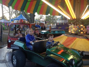 The carnival was and is the widely attended centerpiece of the festivities and is held in McIntire Park. McIntire Park has been a large, popular outdoor recreation venue since the 30’s. Paul Goodloe McIntire financed the land acquisition in the 20’s. McIntire also provided land to the City of Charlottesville for Lee Park, Jackson Park, and Belmont Park. McIntire Park was designed with a rolling, pasture-style layout as well as sports fields, nature trails, playgrounds, and picnic shelters, and during the carnival, it serves as a fair ground. In 1966 the nations’ first Vietnam War Memorial was dedicated during the Dogwood Festival at McIntire Park. The memorial features a gun, helmet, and a pair of boots, and holds a plaque that lists the names of 23 local men who gave their lives in service. It was founded by Jim Shisler and is re-dedicated yearly at the close of the festival with honorary music, the placement of 23 new flags honoring each fallen hero, a relevant speaker, and a 21-gun salute.
The popular Dogwood Track and Field Meet began the tradition of the festival’s skilled running competitions in 1966. The US Army Golden Knights Parachute team were also a big hit of the festival in the 60’s and 70’s. Other notable highlights of the festival throughout time have been the BarBQ, Dogwood tree sale, Benefit “Breakfast in Charlottesville,” movie in the park, the flower show, and the many carnival rides loved by young and old such as the classic, colorful carousel and ferris wheel. As well as providing festivities and commerce for the local community, the festival has carried out and promoted community service through the volunteer activities of the county princesses and queen.
There are other popular dogwood festivals that occur in several cities across the US, including the annual International Dogwood Festival in Winchester (in Franklin County, Tennessee). The Charlottesville version of the Dogwood Festival continues to thrive. Parades, carnivals, good food (including funnel cake), games, prizes and good music continue to please visitors and bring crowds of participants from near and far. For the 65th festival in 2014, hundreds attended the festival kick-off in McIntire Park. For over half a century the Charlottesville Dogwood Festival has ridden the waves of social and cultural change and continues to stand the test of time. As Elizabeth D. Wood Smith, author of The Charlottesville Dogwood Festival and member of the Dogwood Festival Board of Directors, wrote, “The Charlottesville Dogwood Festival takes pride in being a long-standing part of an area rich in tradition and heritage.”
Sources:
http://www.charlottesvilledogwoodfestival.org/index.php
Smith, E. D. (2005). The Charlottesville Dogwood Festival. Charleston SC: Arcadia.
 Barracks